Fantasy cartography
From The Art and Popular Culture Encyclopedia


|
Related e |
|
Featured: |
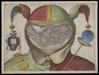
A fantasy map is type of map design that is a visual representation of an imaginary or fictional geography. While some fantasy maps accompany works of fiction and are considered fictional maps, fantasy maps are created to show imaginary places and are not necessarily included in works of literary fiction. Depending on the completeness and complexity of the map, the depiction of geographical components can range from simple drawings of a small area as in The Twenty-One Balloons by William Pene du Bois to an entire fictional world as in The Lord of the Rings by Tolkien to even an entire galaxy as in Star Trek. Fantasy maps can also include abstract works of art, combine existing cartographic information to present an imaginary location, or combine existing cartographic information to show a different perspective of a location.
In popular culture
- Lewis Carroll's Sylvie and Bruno Concluded tells of a fantasy map that had "the scale of a mile to the mile."
- Jorge Luis Borges wrote a short story about a map made to 1:1 scale. It is an homage to Lewis Carroll's work mentioned above. The story, "On Exactitude in Science", is located in a collection called, A Universal History of Infamy.
- J. R. R. Tolkien's Middle-earth is a renowned example of a fantasy map.
- Nikolas Schiller's kaleidoscopic aerial photography of urban areas
See also
- Sentimental cartography
- Somatopia
- Fictional geography
- Cartography
- Fictional world
- List of fictional locations
- Terra incognita
- Lost lands
- Pictorial maps
- Map design and types
- Aeronautical chart
- Cartogram
- Compass rose
- Contour map
- Dymaxion map
- Estate map
- Floor plan
- Geologic map
- Map design
- Nautical chart
- Pictorial maps
- Planform
- Plat
- Reversed map
- Road atlas
- Street map
- Thematic map
- Topographic map
- World map

